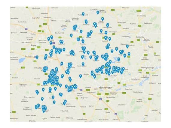
Crime map shows location of antisocial behaviour incidents recorded in Daventry District in past 12 months


Of the total 8,060 crimes included in the police data (released through the national police open data programme), 2,621 were recorded as antisocial behaviour.
The map can be viewed here.
The largest cluster of antisocial behaviour incidents is in Daventry, perhaps unsurprisingly as it has the largest population in the district.
Advertisement
Hide AdAdvertisement
Hide AdOther concentrated areas are found near Moulton, Brixworth, Weedon, Crick and Long Buckby.
In law, antisocial behaviour is defined as “behaviour by a person which causes, or is likely to cause, harassment, alarm or distress to one or more persons not of the same household as the person”.
There are three main categories for antisocial behaviour, depending on how many people are affected.
Personal, when a person targets a specific individual or group; nuisance, when a person causes trouble, annoyance or suffering to a community; and environmental, when actions affect things like public spaces or buildings.
Advertisement
Hide AdAdvertisement
Hide AdUnder those three headings antisocial behaviour falls into one of 13 different types: abandoned vehicle, vehicle nuisance or inappropriate use, rowdy or inconsiderate behaviour, rowdy or nuisance neighbours, littering or drugs paraphernalia, animal problems, trespassing, nuisance calls, street drinking, prostitution-related activity, nuisance noise, begging or vagrancy, or misuse of fireworks.
The data does not provide specific details for each incident, and the location given is approximate covering a street or area rather than exact addresses.